← Home · Investigation

Standard Penetration Test (SPT) in Coquitlam — Field Data for Foundation Design

Together, we solve the challenges of tomorrow.

LEARN MORE →

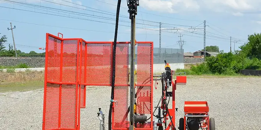
Coquitlam sits on a complex mix of Vashon glacial till, Capilano sediments, and softer alluvial deposits along the Coquitlam and Pitt Rivers. That means you can hit dense, overconsolidated silts at 12 feet in one borehole and find loose, saturated sands at the next lot 200 meters away. When a geotechnical report calls for SPT N-values to confirm bearing capacity near Riverview or along the Lougheed corridor, we mobilize a CME-75 rig and run the test per ASTM D1586. The triaxial lab data often supplements field N-values where silt content is borderline, and we pair the SPT with CPT soundings when the stratigraphy needs continuous profiling without sample disturbance.

A raw N-value of 12 in loose alluvium corrected to (N1)60 of 9 — that's the difference between designing for liquefaction or not in Coquitlam's seismic zone.

Methodology and scope

At an elevation of just 24 meters above sea level, Coquitlam's water table can sit as shallow as 1.5 meters in the low-lying areas north of the Fraser River. That changes how you interpret blow counts — correction for overburden and energy ratio isn't optional here, it is the difference between a safe footing and a settlement problem. Our crew runs the split-spoon sampler with a 140 lb hammer falling 30 inches, recording N-values every 1.5 meters or at every change in material. We log color, moisture, consistency, and any trace of organics right at the rig. These field logs feed directly into the lab's particle-size workflow: once the disturbed samples arrive, we run a grain-size analysis to classify the material per ASTM D2487, which is essential when the field description alone cannot distinguish between silty sand and sandy silt in the transition zones typical of Coquitlam's glaciomarine deposits.
Standard Penetration Test (SPT) in Coquitlam — Field Data for Foundation Design
Technical reference image — Coquitlam

Local considerations

NBCC 2020 puts Coquitlam in a moderate-to-high seismic zone, and the local till can mask loose layers that only show up in the SPT numbers. A site near the Coquitlam River might give you N-values above 30 in the upper 5 meters, then drop below 8 in a saturated sand lens at 8 meters — exactly the kind of profile that triggers a liquefaction assessment under Youd & Idriss (2001) procedures. If that loose layer isn't caught, the foundation design for a townhouse block or a tilt-up warehouse isn't just non-compliant, it's a liability. We run the SPT deeper than the minimum 15 meters when the regional hydrogeology suggests buried channels, and we flag any zone where N1,60cs falls under 15 for further cyclic triaxial testing.

Need a geotechnical assessment?

Reply within 24h.

Email: contact@geotechnicalengineering.vip

Explanatory video

Technical data

ParameterTypical value
Hammer typeSafety hammer, 140 lb (63.5 kg)
Drop height30 inches (760 mm)
SamplerStandard split-spoon, 2-inch O.D.
Standard test intervalEvery 1.5 m depth or at material change
Penetration recorded150 mm (6") per increment, N = sum of last 300 mm
Energy correction methodER measured per ASTM D4633, normalized to 60% theoretical energy
Sampling classificationDisturbed sample, bagged and labeled per ASTM D4220

Associated technical services

01

Borehole drilling and SPT execution

Mobilization with track-mounted CME-75 rig. We advance the borehole with hollow-stem augers, run the SPT at specified intervals, and recover split-spoon samples in plastic-lined bags.

02

Energy calibration and N60 correction

Hammer energy ratio measured on-site per ASTM D4633. Every blow count is corrected to N60, and we apply overburden correction (CN) per Liao & Whitman for granular soils.

03

Field logging and soil classification

Visual-manual classification at the rig per ASTM D2488. Each sample logged for moisture, color, plasticity, and organic content before transport to the lab.

04

Liquefaction screening package

We run the simplified procedure (Youd & Idriss 2001) using corrected N1,60cs values. Report includes factor of safety against liquefaction at each critical layer, ready for seismic design review.

Applicable standards

ASTM D1586-18: Standard Test Method for Standard Penetration Test (SPT), ASTM D4633-16: Standard Test Method for Energy Measurement for SPT, ASTM D2487-17: Unified Soil Classification System (field and lab correlation), NBCC 2020 Division B, Part 4: Seismic Design Provisions

Quick answers

What depth do you typically drill for SPT in Coquitlam?

Most residential and low-rise commercial jobs go to 15 meters below ground surface. If the site is near the Pitt or Coquitlam River floodplain, we often extend to 20 meters to catch buried soft layers that control settlement and liquefaction risk.

How long does an SPT program take on site?

A single borehole to 15 meters in typical till takes about 4 to 6 hours with setup and cleanup. Two-borehole programs usually wrap in one working day, plus lab turnaround time if samples are sent for grain-size or Atterberg limits.

What is the typical cost for SPT testing in Coquitlam?
Do you provide N60-corrected values directly in the field log?

Yes. We measure hammer energy ratio during the test and apply the correction on-site. The field log shows both raw N-values and corrected N60, so the geotechnical engineer can use the data immediately for bearing capacity or liquefaction checks.

Location and service area

We serve projects across Coquitlam and surrounding areas.

View larger map